- Membership
- Perks and Discounts
- Things To Do
- Resources
- News
- About
- Shop
Related Content
Women’s Soccer Coach Dorrance Retires
Aug. 13, 2024
Anson Dorrance ’74, women’s soccer head coach and one of the most successful coaches in...
Read MoreRoberts Next UNC Chancellor
Aug. 9, 2024
Lee Roberts was named today the 13th chancellor of UNC, after serving in the role...
Read MoreDenied UNC Applications Can Be Redirected to Other State Schools
Aug. 7, 2024
The UNC System hopes to increase enrollment at certain institutions by launching three pilot programs...
Read More-
2024
-
2023
-
2022
-
2021
-
2020
-
2019
-
2018
-
2017
-
2016
-
2015
-
2014
-
2013
-
2012
-
2011
-
2010
-
2009
-
2008
-
2007
-
2006
-
2005
-
2004
- Academics and Athletics
- Admissions
- Alumni Profiles
- Alumni Recognition
- Around Town
- Arts
- Books
- Campus Profile
- Campus Safety
- Carolina Alumni Awards
- Carolina Alumni Leadership
- Carolina Alumni Programs and Outreach
- Carolina Alumni Reunions
- Carolina Alumni Review
- Celebrations
- Championships
- College and Costs
- Commencement
- Coronavirus
- Discovery
- Extracurricular
- Faculty
- Faculty Awards
- For the People
- Go Heels
- Greek Life
- Hark the Sounds
- Higher Education
- Homecoming
- In Class
- In Memoriam
- Innovation and Technology
- Issues
- Object Lesson
- On View
- Our Treescape
- Philanthropy
- Podcast
- Public Service
- Race and Reckoning
- Research
- Sexual Assault
- Silent Sam
- Sports
- Structures
- Student Achievement
- Students
- Timelines
- Tuition and Financial Aid
- UNC Libraries
- UNC’s History
- Undergraduate Spotlight
- University Achievements
- University Awards
- University Budget Issues
- University Development
- University Leadership
- University News
- University Rankings
- What We Do
- Who We Are
- Young Alumni
- Yours at Carolina
Students Work to Cool Campus
Posted on Aug. 5, 2024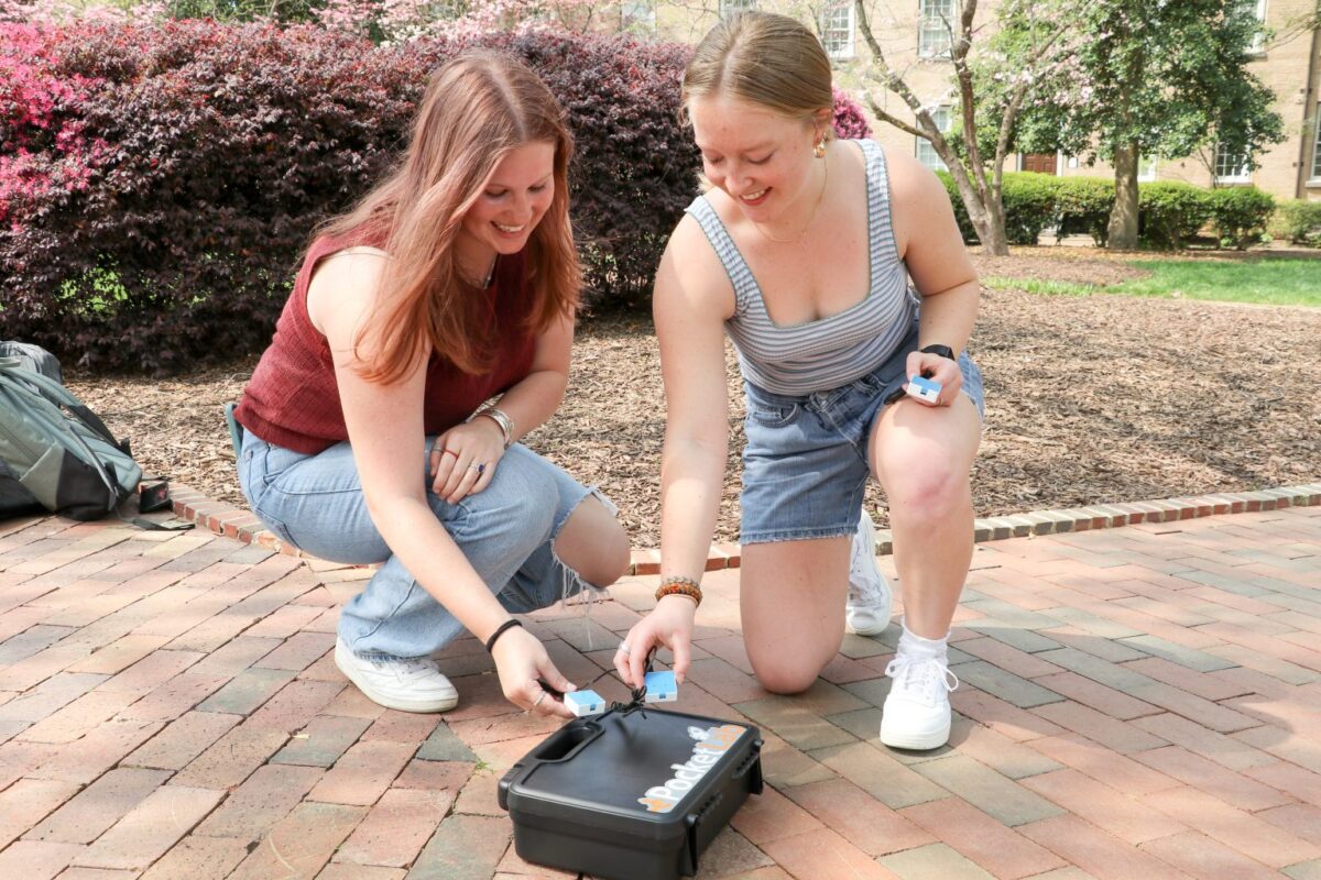
Data gathered by students during a spring semester class is being used to help identify specific foot-traffic corridors on campus that would benefit from additional tree canopy in hopes of reducing the number of high-temperature areas. (Photo: UNC)
Data gathered by students during a spring semester class is being used to help identify specific foot-traffic corridors on campus that would benefit from additional tree canopy in hopes of reducing the number of high-temperature areas.
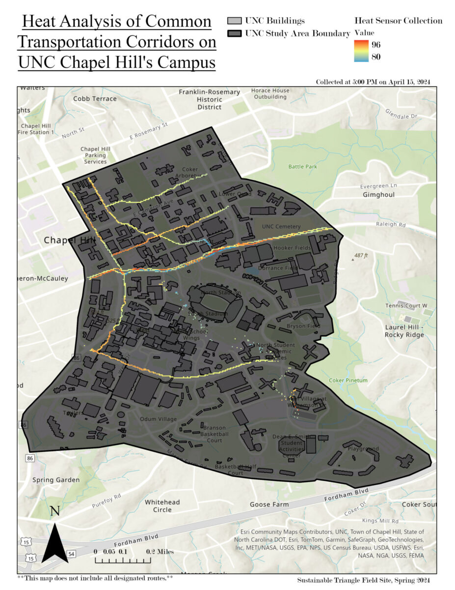
The students created maps pinpointing so-called heat islands on campus as part of the Sustainable Triangle Field Site, a research project established in 2008 to support sustainability on campus, including reducing water use, energy and waste.
The maps have been given to the University’s landscape architect and arborist, and will be useful “especially as temperatures will only get hotter in the future,” said Antonia Sebastian, director of the Sustainable Triangle Field Site. The students’ research will also be used to create a policy brief for the University to use as justification for more tree canopies on campus.
Their work is particularly important because of climate change. July 22 was “most likely” the hottest day ever recorded on Earth, with a global average of about 62.87 degrees Fahrenheit, according to The New York Times. The average temperature on July 22 beat a record that had been set the previous day, The Times reported, citing researchers with the European Union’s Copernicus Climate Change Service.
Sebastian told Media Relations since becoming director of STFS she has “sought out projects that focus on sustainability challenges that are driven in part by extreme weather and climate-related events and how they further stress communities.”
The maps have been given to the University’s landscape architect and arborist, and will be useful “especially as temperatures will only get hotter in the future,” said Antonia Sebastian, director of the Sustainable Triangle Field Site. (Photo: UNC)
The students, many of whom were conducting their first research, walked 10 routes across campus at different times of the day collecting temperature and humidity data. The students’ research showed that areas in close proximity to buildings recorded higher temperatures, as well as areas close to roads. They also found areas with older trees, such as McCorkle Place, have lower temperatures because of the tree canopy, according to a website of their findings.
Sebastian said project goals included helping students learn how to multitask, to master basic research and to collect and analyze data while identifying their strengths.
“From semester-to-semester, the projects can range anywhere from mapping, communicating and managing environmental challenges, like extreme weather and climate events, to preserving natural resources to planning and evaluating proposed infrastructure,” she said.
Other projects in the STFS include collecting water-level data in Chapel Hill creeks during heavy precipitation and gathering data on the performance of green infrastructure, including green roofs, and providing recommendations on how to incorporate them on campus, Sebastian said.
To learn more about the Sustainable Triangle Field Site, visit their website.

© 2024 Carolina Alumni